


 expands to Sint Maarten with first grant awarded to future Alvin Ailey Dancer")


***LAST UPDATE (9:00pm)
 PHILIPSBURG, St. Maarten – An earthquake rattled the nerves of many residents on St. Maarten Thursday afternoon.
The earthquake was felt at approximately 6:30 Thursday afternoon, shaking structures after a distant rumble was heard.
Many residents referred to Thursday afternoon’s earthquake as a “strong jolt”.
Initial information received by this website from the USGS gives the following information.
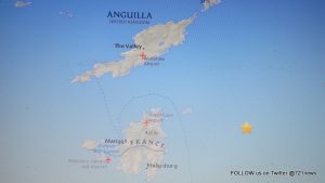
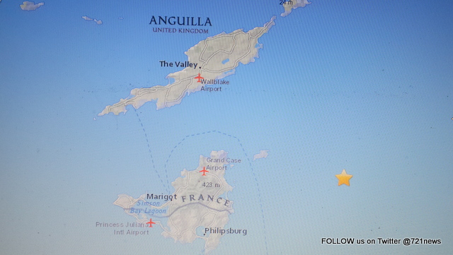
The Earthquake was registered at a magnitude of 3.8 on the Richter scale and was located 19km ENE of Philipsburg, Sint Maarten and took place at the recorded time of 2015-07-30 22:28:57 (UTC).
It was located at 18.095°N and 62.881°W at a depth of 34.6 km (21.5 mi)
According to the Department of Communications, the Meteorological Department of St. Maarten (MDS) confirmed that there was a 3.8 magnitude earthquake 19 kilometers/12 miles East north east of the country St. Maarten.
###
M3.8 – 19km ENE of Philipsburg, Sint Maarten
Time
- 2015-07-30 22:28:57 (UTC)
- 2015-07-30 19:28:57 (UTC-03:00) in your timezone
- Times in other timezones
Nearby Cities
- 19km (12mi) ENE of Philipsburg, Sint Maarten
- 90km (56mi) N of Basseterre, Saint Kitts and Nevis
- 153km (95mi) NW of Saint John’s, Antigua and Barbuda
- 218km (135mi) E of Charlotte Amalie, U.S. Virgin Islands
- 232km (144mi) NNW of Sainte-Rose, Guadeloupe
*** Early Post !!! ***
PHILIPSBURG, St. Maarten – An earthquake rattled the nerves of many residents on Thursday afternoon.
The earthquake was felt at approximately 6:30 Thursday afternoon, shaking structures after a distant rumble was heard.
Many residents referred to Thursday afternoon’s earthquake as a “strong jolt”.
Initial information received by this website from the USGS gives the following information.
The Earthquake was registered a magnitude of 3.8 on the Richter scale and was located 170km NNW of The Valley, Anguilla and took place at the recorded time of 2015-07-30 03:28:56 UTC. It was located at 19.715°N and 63.442°W at a depth of 129.0 km.
Source sxmislandtime.com
http://earthquake.usgs.gov/earthquakes/eventpage/us10002wht#general_summary


