


 expands to Sint Maarten with first grant awarded to future Alvin Ailey Dancer")


By NOAA NWS National Hurricane Center
On this Saturday morning, a tropical wave is located over the tropical Atlantic Ocean about 1500 miles east-southeast of the southern Windward Islands, producing scattered showers and thunderstorms.
This disturbance has changed little in organization since yesterday. However, some development is expected during the next few days before conditions become less favorable for tropical cyclone formation.
This system is expected to continue moving toward the west or west-northwest at 15 to 20 mph over the tropical Atlantic during the next several days.
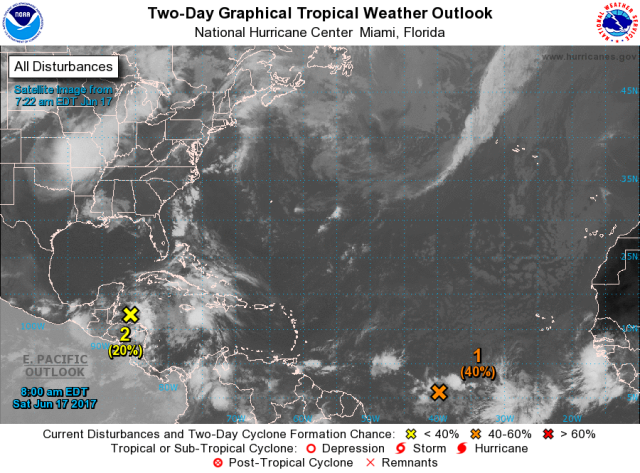
In addition, a broad trough of low pressure is producing a large area of cloudiness and showers over the northwestern Caribbean Sea and the adjacent land areas.
Conditions appear to be favorable for gradual development of this large disturbance while it moves slowly northwestward across the Yucatan Peninsula this weekend, and a tropical cyclone could form early next week over the southern or central Gulf of Mexico.
Regardless of development, heavy rains are likely to spread over portions of Central America, the Yucatan Peninsula, Jamaica, the Cayman Islands, and western Cuba during the next several days
Get the latest on the tropics by visiting the NHC website at www.hurricanes.gov


