
")
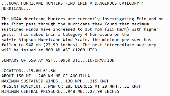
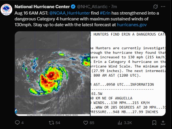
6:00am UPDATE / JUST IN BY NOAA: Hurricane Erin Cat #4 !!!


SPECIAL WEATHER BULLETIN # 7
| DATE ISSUED: Saturday, 16 August 2025 TIME: 5:05 AM (09:05 UTC) |
…A TROPICAL STORM WATCH IS IN EFFECT FOR ST. MAARTEN…
…A FLOOD ADVISORY IS IN EFFECT…
…A SMALL CRAFT ADVISORY IS IN EFFECT…
At 5:00am, the center of Hurricane Erin was located near latitude 19.8 North, longitude 61.1 West or about 180 miles northeast of St. Maarten.
The system is moving toward the west-northwest near 20 mph (31 km/h). This motion is expected to continue through the weekend with a gradual decrease in forward speed. On the forecast track, the center of Erin is likely to pass approximately 145 miles north-northeast of St. Maarten later this morning.
Maximum sustained winds are up to 120 mph (195 km/h) with higher gusts. Continued rapid strengthening is expected, and Erin could become a Category 4 Hurricane later today. Hurricane-force winds extend up to 30 miles (45 km) from the center. Tropical-storm-force winds extend up to 125 miles (205 km) from the center.
The estimated minimum central pressure is 955 mb (28.20 inches).
HAZARDS AFFECTING LAND:
- RAINFALL: The outer bands of Erin could produce rainfall accumulation of up to 2 to 4 inches (possibly up to 6 inches in some areas). This could be accompanied by thunderstorms, which would likely cause street-flooding and/or rock-falls. Hence, a Flood Advisory is in effect!
- Winds: Strong breezes, with gusts up to 40-50 mph could be expected on St. Maarten. • Seas: Rough seas (up to 9 feet), mainly along the northern and eastern shores with ground swells are expected. Interests along the coast should take the necessary actions to preserve life and property. A Small Craft Advisory is in effect until further notice, which may be upgraded to a Small Craft Warning later today.
The public is urged to remain alert and monitor subsequent updates, and monitor updates from the Meteorological Department and Disaster Management.
Next Bulletin: 11:00am today, Saturday 16 August 2025
FORECASTER: CONNOR
A Special Weather Bulletin is issued for weather events that are unusual, cause general inconvenience or public concern (requiring the attention and action of emergency authorities) and cannot adequately be described in a regular weather forecast.
A Small Craft Advisory announces that the sea will likely become rough today or is already occurring. A Small Craft Warning means that winds above 33 kts and/or waves above 10 feet are expected within 6 hours or are already occurring.
A Flash Flood Alert/Advisory announces that heavy rainfall will occur today or is already occurring.
Tropical Storm is a cyclone with sustained winds between 34-63 knots (39-73 mph). A hurricane is a cyclone with sustained winds 64+ knots (74+ mph).
A Tropical Storm Watch means that tropical storm conditions are possible within the watch area, in this case within 12 hours.


